(OARS “Rim to River” guided tour puts the unparalleled experience of hiking down to the bottom of the Grand Canyon –a full mile in altitude – within reach. After hiking the spectacularly scenic 7-mile South Kaibab Trail, overnighting at the historic Phantom Ranch, and hiking back up to the South Rim on the Bright Angel Trail, we have the evening and part of the next day to explore the South Rim. But the trip begins with a full day exploring Native American sites. Our adventure continues from 4/1, 4/8, 4/15, 4/22, 4/29 columns.)
I had focused on the extraordinary opportunity to hike into the depths of the Grand Canyon when I joined OARS’ new “Rim to River’ program but an unexpected bonus were the visits to important archaeological sites on our first-day – the extraordinary cliff dwellings of Walnut Canyon, the centuries old Pueblos and structures of Wupatki, and the Sunset Crater Volcano that erupted so violently 1000 years ago, forcing people to flee their communities they had inhabited for 400 years.
This extra day is part of the “luxury” that is built into the OARS program – the luxury of time that allows us to not only acclimate and warm up our legs on short hikes before we tackle the Grand Canyon, but it so enriches our understanding and appreciation of this place. It reminds us of the human presence in this and how this land is still a spiritual place.
After our orientation meeting Saturday night, we set off at 8:30 am Sunday morning from the Doubletree in Flagstaff, stop off at a hip coffee place, and then to pick up sandwiches, and head out.
Walnut Canyon National Monument
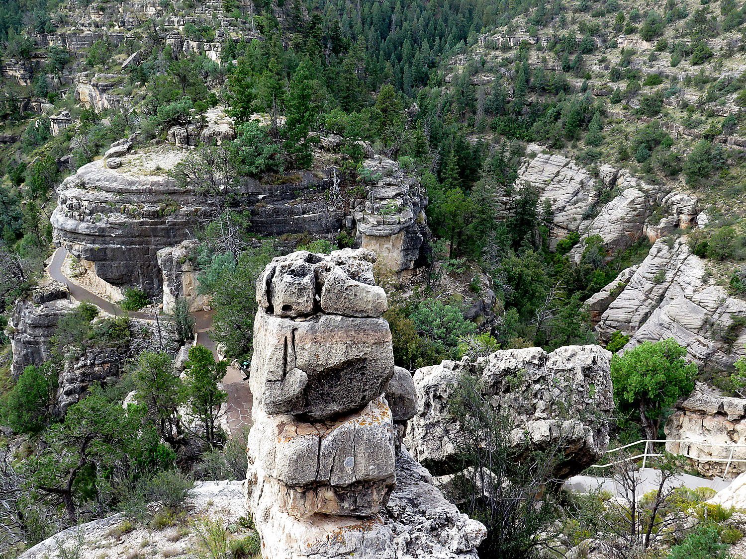
Nestled in this 600-foot deep canyon, there are more than 80 abandoned cliff dwellings thought to be constructed more than 800 years ago. When the Sinagua people arrived in the canyon they discovered natural overhangs which had been carved into the limestone walls by Walnut Creek. In this deeply forested canyon, they proceeded to build their dwellings in these protected alcoves.
Like many other ancient tribes, the Sinagua suddenly abandoned their dwellings. It is thought their departure was due to the threat of drought or nearby tribes.
We get a close-up look at several of these one-story structures, remarkably well preserved, still quite intact, walking along the park’s one-mile long dirt Island Trail. The trail descends 185 feet into the canyon, skirting along the dwellings built under the cliffs. It is hard to imagine how people actually lived here – each of the “homes” seems to isolated from one another, and just steps from the “front door” are sheer drops down the canyon. But we see evidence of where there would have been cooking stoves and rooms. Ryan says there might have been 50 people living here.
The cliff dwellings were built between 1125 and 1250, and the people probably lived here for 100 years. These were the years of the Sinagua culture’s greatest expansion. Settlements ranged from the eastern slopes of the San Francisco Peaks northeast of here to the Little Colorado river and south to the Verde River valley. Trade items found in Sinagua dwellings include turquoise form the Santa Fe area, seashell ornaments from the Gulf of Mexico and the Gulf of California and macaw feathers from Mexico. The artifacts may have been acquired by intermediaries who arranged traded with other groups.
Why here? Why build homes in cliffs? I wonder. “It was easy to build protection; there was water here, then a massive drought,” Jon says. The Sinagua (Spanish for “without water”) were remarkable for their ability to turn a relatively dry region into a homeland, taking advantage of the region’s abundant plants and animals, but also farming.
The canyon also offers a diverse variety of vegetation from Ponderosa pines and fir to cactus, cholla and walnut trees, for which the canyon was named. Ryan, who is a wiz about plants – points out willow bark, which supplies aspirin; “Mormon tea” – a plant that when brewed, provides ephedra, a stimulant (used today in diet pills); skunkbush.
The trail follows the original trails the Indians would have used.
It isn’t known why the people left, but by 1250 they moved to new villages a few miles southeast along Anderson Mesa. It is generally believed they were eventually assimilated into Hopi culture. The Hopi refer to their ancestors as Hisatsinom – “people of long ago”.
Returning to the rim is an upward climb of 240 steps which can be quite strenuous since the elevation is over 6,600 feet. We imagine that our guides, Jonathan and Ryan, are checking out our group of five hikers, culling the herd for those who won’t make it the one-mile elevation, down and up, the Grand Canyon.
The area was largely undisturbed until the 1880s when the railroad brought souvenir hunters to the ancient dwellings. Theft and destruction prompted local efforts to preserve the canyon. In 1915, Walnut Canyon was declared a national monument.
I’m told the Museum of Northern Arizona in Flagstaff on I-180 has artifacts that were collected from these sites. I make a note.
Sunset Crater Volcano
Roughly 900 years ago, the eruption of the Sunset Crater Volcano reshaped the landscape, forever changing the lives of people, plants and animals. The people in the area would have felt the tremors, would have seen the plume. It is believed that the eruption began sometime between 1040 and 1100 and lasted a few months or years.
Here we get to hike a mile-long Lava Flow Trail, following the lava flow and cinders and reveling in the colorful, ruggedly dramatic geological features amid twisted Ponderosa Pines.
This is a cinder cone volcano which is different than a volcano, Jon explains. Because of the way it erupts, throwing up lava that cools on way down, what it leaves are tiny stones, as opposed to a hardened mass. The composition of the material here is chemically the same that made up Hawaii.
There are over 200 cinder cone volcanoes in this area.
The landscape is dramatic, but what is really astonishing are the occasional plants. We see small amounts of plant growth, and realize that it has taken 1000 years to grow even this much. Some of the plants are absolutely gorgeous, like Apache Plume, which has a pinkish flower.
The Sunset Crater Volcano is contained within the 56 square miles of the Wupatki National Monument.
Remarkably, only 100 years after the eruption, human settlements returned. We drive a bit further to see the Puebloan ruins at Wupatki.
Wupatki National Monument
Over 900 years ago, the eruption of Sunset Crater Volcano in Arizona forced the people living in the region of present day Flagstaff to evacuate their homes and the lands they had cultivated for 400 years. The lava and cinder debris burned and covered the Ancestral Puebloan pithouses. The eruption not only destroyed homes, but it also changed the land, making it difficult for the Sunset Crater community to grow crops. The farmers relocated to nearby lands in northeast Flagstaff, where less ash and cinder had fallen. Wupatki National Monument protects one of five Ancestral Puebloan ruins on the outskirts of Sunset Crater, according to the National Park Service notes.
Although the soil in their new homeland contained small traces of ash, residents of Wupatki and nearby pueblos realized that their agricultural community could benefit from the unique volcanic terrain. To sustain their community in the arid climate, the Ancestral Puebloans used dry farming techniques that allowed them to harvest corn, squash, and beans in the region’s nutrient poor soil. Archeologists named these people the Sinagua, for their ability to sustain their community and farmland “without water.”
Established in the 1100s, Wupatki was the tallest and largest of these newly formed pueblos. Its homes ranged from one-story single-family structures to multi-level 100-room dwellings. Although most of these rooms served as residences, some were for storage and others were for processing food. The Wupatki design demonstrates that the people recognized the need to store food in case of droughts and crop failure. Despite the volcanic moisture in the terrain, unreliable weather remained an important factor and the pueblo Indians often performed religious ceremonies to ask the spirits to bring rain and good fortune to their lands.
The circular ruin at Wupatki resembles a great kiva—a subterranean structure where Puebloans gathered and performed their religious ceremonies. The kiva is the lowest structure in Wupatki. The tallest dwelling at the site stands three stories high, with double walls measuring up to six feet tall. To fill in these double walls, the Wupatki pueblo people used rubble, and to build their masonry dwellings, they used sandstone slabs, limestone blocks, and chunks of basalt cemented with a clay-based mortar. The Wupatki residents also designed a ventilation system that allowed them to build fires within their homes.
The people who built Wupatki and other pueblos here were ancestors of the Hopi, Zuni, and other Puebloan peoples of today. Archeologists recognize different cultural traditions based on differences in pottery styles and architecture. According to these classifications, most of the monument’s sites are called Kayenta Ancestral Puebloan; others are Cohonina, and Sinagua. But these are modern terms. It is not known what the people called themselves or how different groups related to each other.
Artifacts have been unearthed indicating they were also gifted artisans and traders. The Visitor Center has wonderful displays of artifacts and photos and commentary. You can look at a map with 3D glasses that is a timeline of population size in various areas.
The monument has many well-preserved pueblo ruins scattered throughout the site, which are easily accessible by following the self-guided trails. It’s a short walk from the Visitor Center to the largest pueblo which may have housed up to 100 people, like an apartment house.
One of the most fascinating places is the blow hole – a geologic phenomenon where the earth appears to breathe (Ryan demonstrates by putting his hat over it) – and made this place a spiritual center. Hopi descendants of the original builders call it “Yaaponsta” (the Wind Spirit).
It’s easy to walk passed it without even noticing the blow hole, because it looks like a square sandstone bench.
The blow hole is a crevice in the earth’s crust that connects to an earth crack, an underground passage formed by earthquake activity in the Kaibab limestone bedrock. The hole reacts to barometric pressure above ground. When the air is warm and light above, the cold air from below blows out with significant force. But when the air gets heavy and moist, it reverses and sucks the air down.
“Think of what the Indian people would have thought of a place where the earth was breathing” Ryan says. There are several such blow holes in the area, Ryan says, and he has even climbed down 200 ft. into one of the larger ones.
Nearby is a ball court, reminiscent of Mexico. Indeed, it is testimony to the trade and transference of culture among the southwestern people and how the Wupatki pueblo served as an important center for trade. Exotic items have been found, including copper bells from Mexico, shell beads, and the remains of more than 40 macaws from Mesoamerica.
“Until Wupatki was abandoned in 1250, it was a meeting place where different cultures exchanged ideas in the ceremonial ball court and traded goods to meet their needs. Tribes from the Hohokam tradition who were living in the southern region brought shells, salt, and cotton, and the communities of the Ancestral Puebloan tradition traded copper and turquoise. Among those who traded at Wupatki were the Sinagua Indians from nearby pueblos, Navajo families, and other ancestral Puebloans whose descendants still live nearby. Today, the ruins of Wupatki, and the nearby pueblos of Wukoki, Citadel, Nalakihu, and Lomaki continue to be sacred to the Hopi, Zuni, and Navajo people.”
You start your exploration of Wupatki National Monument at the visitor center, where museum exhibits tell the stories of the people who lived in Wupatki and surrounding pueblos. Leaving the visitor center, you follow the Wupatki Pueblo Trail on a 30-minute self-guided tour of the largest of five pueblos located within the boundaries of the Wupatki and Sunset Crater Volcano National Monuments.
There are other trails, including a half-mile long Lomaki Pueblo Trail to the Box Canyon Pueblos; the Doney Mountain Trail, another half-mile long trail from the picnic area to the top of the cinder cone; and several .2 mile long trails to the Wukoki, Citadel, and Nalakihu Pueblos. Touring all five pueblos takes approximately two hours.
The Citadel
We continue driving through this stark, vast landscape until we come to a structure which is called “the Citadel”. It is fairly mysterious – Jon says that archeologists don’t really know what it was. But it commands a view and it is possible it was a watch tower. I see the remains of small rooms and hypothesize that they might have been store rooms, perhaps for grain.
We climb to the top and take out our picnic lunch, the wind whipping about. Except for the wind, there is complete silence. It is quite amazing.
In the distance, we can see remains of another structure as well.
Then we continue driving. The landscape is dramatic. The Interstate takes us right through the Navajo Reservation. It is remarkably barren – a few shacks, trailers, a traditional eight-sided hogan, but little else. No village. No main street. No shops or restaurants beyond a trading post here or there, and the biggest of all, the Cameron Trading Post, created by Ralph Cameron, a miner who laid claim to much of the Grand Canyon and soon realized he could make more money from tourists than ore (he charged a $1 toll to hike the Bright Angel Trail which he claimed.)
When Cameron refused to give up his claim to the Bright Angel Trail, the only trail into the Grand Canyon at the time, the federal government, which had designed the Grand Canyon a National Park in 1919, built the South Kaibab Trail. We get to hike both of these on the OARS Rim to River program over the course of the next two days.
OARS Rafting Company Expands Hiking Tours
The Rim to River hiking program in the Grand Canyon, is relatively new for OARS, which is famous for its rafting and sea kayaking programs.
O.A.R.S. was the first exclusively oar-powered rafting company permitted to operate trips on the Colorado River through the Grand Canyon.
Indeed, OARS offers programs which split the Grand Canyon rafting trip in half, so that you hike up the Bright Angel Trail from the Phantom Ranch after spending about six days on the Colorado River, or hike down into the cavern and switch places with the rafters for the eight or nine day trip down from the Phantom Ranch pull-out.
Jason Dosch, who designed the Rim to River Grand Canyon hiking program for OARS, had described it as “luxury.” At first I wondered about that as I was slogging around in mud and muck. But it is a luxury not to have to carry down heavy packs, and have what you need for the overnight carried down for you. And being able to sleep in a bed (albeit a bunkbed) in a cozy stone cabin with a roof over your head, electric lights and running water (toilets), is a luxury in the wilderness of the Grand Canyon. And certainly, our celebratory dinner and breakfast at the historic El Tovar Hotel on the South Rim is the peak of luxury.
Having time is the greatest luxury of all – designing the trip by spending most of our first day together exploring significant archeological sites outside of Flagstaff. And there is luxury in the pacing of the trip – we have much of a third day at the Grand Canyon to explore (had I known, I would have arranged for a rental bike to go along the 14.8 mile South Rim trail).
The success of OARS’ Grand Canyon hiking program has sparked other new hiking programs in Morocco, and Italy’s Amalfi Coast.
OARS (which stands for (Outdoor Adventure River Specialists) is renowned for its rafting and kayaking trips, offers multi-sport trips, special interest, family adventures, adult and singles vacations, among other styles of outdoor adventure travel.
Through four decades in the adventure travel industry, the company has become one of the largest river-based adventure travel companies in North America, operating on over 1230 miles of rivers in the continental U.S. In addition to its signature Grand Canyon trips, OARS offers adventure vacations in Alaska, California, Colorado, Idaho, Oregon, Utah and Wyoming, as well as in British Columbia, Chile, Galapagos, Fiji, Baja and Peru.
True to founder George Wendt’s original vision, OARS has remained committed to the cultural and environmental well-being of the places it visits. “We follow expertly designed on-the-ground practices and seek to create inspirational experiences for guests and students. The company supports a variety of institutions that further these ideals, including: the Leave No Trace Center for Outdoor Ethics, American Whitewater, Friends of the River, Environmental Defense Fund, Waterkeeper Alliance, the Grand Canyon Trust, Hells Canyon Preservation Council, Idaho Rivers United, Alaska Wilderness League, the International Galapagos Tour Operators Association, the Outdoor Foundation, the International Ecotourism Society and Sustainable Travel International.”
Over 40 years, OARS and its guests have contributed more than $3 million toward the protection and preservation of the places and communities visited on its tours. Its California headquarters and other operations warehouses run on solar power, and the tour operator utilizes alternative energy sources such as bio-diesel along with fuel-efficient vehicles and support vessels whenever possible to reduce its carbon footprint.
The company has received many awards and accolades: National Geographic Adventure magazine has recognized OARS as “The Best River & Sea Outfitter on Earth” multiple times based on education, sustainability, quality of service, spirit of adventure and references. National Geographic, Outside, Men’s Journal, Sunset and other publications have recognized O.A.R.S. as serving up some of the “Best Trips on the Planet.”
OARS has scheduled 22 departure dates and prices for the 4 Day Grand Canyon Rim to River Hiker in 2016, from April through October. Departures are limited to 9 people in most cases. The trip meets up at the DoubleTree by Hilton, Flagstaff, Arizona. Prices range from $1499 to $1649, based on double occupancy, single supplement $200. See: www.oars.com/grandcanyon/hiking/grand-canyon-hiking.html
Contact OARS, Angels Camp, CA, 800-346-6277, 209-736-4677, oars.com, info@oars.com.
__________________
© 2016 Travel Features Syndicate, a division of Workstyles, Inc. All rights reserved. Visit goingplacesfarandnear.com, www.examiner.com/eclectic-travel-in-national/karen-rubin,www.examiner.com/eclectic-traveler-in-long-island/karen-rubin, www.examiner.com/international-travel-in-national/karen-rubin and travelwritersmagazine.com/TravelFeaturesSyndicate/. Blogging at goingplacesnearandfar.wordpress.com and moralcompasstravel.info. Send comments or questions to FamTravLtr@aol.com. Tweet @TravelFeatures. ‘Like’ us at facebook.com/NewsPhotoFeatures